Tiedosto:Messina Chasma.jpg
Siirry navigaatioon
Siirry hakuun
Tarkempaa kuvaa ei ole saatavilla.
Messina_Chasma.jpg (150 × 440 kuvapistettä, 7 KiB, MIME-tyyppi: image/jpeg)
| Tämä tiedosto on tiedostotietokanta Wikimedia Commonsista. Tiedot kuvaussivulta näkyvät alla. |  |
Tiedoston kuvaussivu Commonsissa |
Yhteenveto
| Kuvaus |
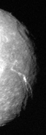
English: Original caption: The terminator region of Titania, one of Uranus' five large moons, was captured in this Voyager 2 image obtained in the early morning hours of Jan. 24, 1986. Voyager was about 500,000 kilometers (300,000 miles) from Titania and inbound toward closest approach. This clear-filter, narrow-angle view is along the terminator -- the line between the sunlit and darkened parts of the moon. The low-angle illumination shows the shape of the surface very clearly. Among the features visible are long linear valleys perhaps 50-100 km (30-60 mi) wide and several hundred km (or mi) long. At least two directions of faulting are visible, as are many circular impact craters attributed to cosmic debris. The resolution of this image is about 9 km (6 mi). The Voyager project is managed for NASA by the Jet Propulsion Laboratory. |
| Päiväys | |
| Lähde | http://photojournal.jpl.nasa.gov/catalog/PIA01978 |
| Tekijä | NASA/JPL |
Lisenssi
| Tämä teos on ilman tekijänoikeuden suojaa, koska National Aeronautics and Space Administration (NASA) loi sen. Koska Nasa on Yhdysvaltain liittovaltion organisaatio, sen luomat teokset ovat ilman tekijänoikeuden suojaa. ([1][2]) | ||
 |
Varoitukset:
|
Tiedoston historia
Päiväystä napsauttamalla näet, millainen tiedosto oli kyseisellä hetkellä.
| Päiväys | Pienoiskuva | Koko | Käyttäjä | Kommentti | |
|---|---|---|---|---|---|
| nykyinen | 25. kesäkuuta 2009 kello 14.16 | 150 × 440 (7 KiB) | Ruslik0 | {{Information |Description={{en|1='''Original caption''': The terminator region of Titania, one of Uranus' five large moons, was captured in this Voyager 2 image obtained in the early morning hours of Jan. 24, 1986. Voyager was about 500,000 kilometers (3 |
Tiedoston käyttö
Seuraava sivu käyttää tätä tiedostoa:
Tiedoston järjestelmänlaajuinen käyttö
Seuraavat muut wikit käyttävät tätä tiedostoa:
- Käyttö kohteessa ar.wikipedia.org
- Käyttö kohteessa be-tarask.wikipedia.org
- Käyttö kohteessa ca.wikipedia.org
- Käyttö kohteessa de.wikipedia.org
- Käyttö kohteessa en.wikipedia.org
- Käyttö kohteessa es.wikipedia.org
- Käyttö kohteessa fr.wikipedia.org
- Käyttö kohteessa gl.wikipedia.org
- Käyttö kohteessa hy.wikipedia.org
- Käyttö kohteessa id.wikipedia.org
- Käyttö kohteessa it.wikipedia.org
- Käyttö kohteessa mwl.wikipedia.org
- Käyttö kohteessa pt.wikipedia.org
- Käyttö kohteessa ro.wikipedia.org
- Käyttö kohteessa ru.wikipedia.org
- Käyttö kohteessa uk.wikipedia.org
- Käyttö kohteessa www.wikidata.org
- Käyttö kohteessa zh.wikipedia.org