Tiedosto:Satellite image of Bangladesh in October 2001.jpg
Siirry navigaatioon
Siirry hakuun

Tämän esikatselun koko: 554 × 599 kuvapistettä. Muut resoluutiot: 222 × 240 kuvapistettä | 444 × 480 kuvapistettä | 710 × 768 kuvapistettä | 947 × 1 024 kuvapistettä | 2 214 × 2 394 kuvapistettä.
Alkuperäinen tiedosto (2 214 × 2 394 kuvapistettä, 674 KiB, MIME-tyyppi: image/jpeg)
| Tämä tiedosto on tiedostotietokanta Wikimedia Commonsista. Tiedot kuvaussivulta näkyvät alla. |  |
Tiedoston kuvaussivu Commonsissa |
| Kuvaus |
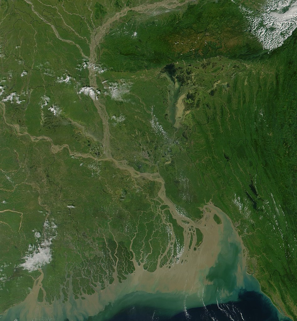
Satellite image of Bangladesh in October 2001 True-color MODIS image from October 23, 2001. Lush with vegetation to the south, numerous rivers, brown with churned up sediment, flow into the valley of the Brahmaputra River in Assam, India. The Brahmaputra turns southward at the border of Bangladesh and is soon joined by the Ganges River, flowing in from image left. The mighty river splits into numerous channels as it runs out toward the Bay of Bengal, giving the region the name "Mouths of the Ganges." Vast amounts of sediment are being emptied into the Bay by the river, and greenish blue swirls could be a mixture of sediment and phytoplankton. |
| Päiväys | |
| Lähde | Cropped from Visible Earth |
| Tekijä | Jacques Descloitres, MODIS Land Rapid Response Team, NASA/GSFC |
| Tämä teos on ilman tekijänoikeuden suojaa, koska National Aeronautics and Space Administration (NASA) loi sen. Koska Nasa on Yhdysvaltain liittovaltion organisaatio, sen luomat teokset ovat ilman tekijänoikeuden suojaa. ([1][2]) | ||
 |
Varoitukset:
|
Tiedoston historia
Päiväystä napsauttamalla näet, millainen tiedosto oli kyseisellä hetkellä.
| Päiväys | Pienoiskuva | Koko | Käyttäjä | Kommentti | |
|---|---|---|---|---|---|
| nykyinen | 18. joulukuuta 2004 kello 18.38 | | 2 214 × 2 394 (674 KiB) | Hautala | {{PD-USGov-NASA}} Satellite image of Bangladesh in October 2001. Original image taken from NASA's Visible Earth http://visibleearth.nasa.gov/cgi-bin/viewrecord?10722 |
Tiedoston käyttö
Seuraava sivu käyttää tätä tiedostoa:
Tiedoston järjestelmänlaajuinen käyttö
Seuraavat muut wikit käyttävät tätä tiedostoa:
- Käyttö kohteessa af.wikipedia.org
- Käyttö kohteessa ar.wikipedia.org
- Käyttö kohteessa ast.wikipedia.org
- Käyttö kohteessa as.wikipedia.org
- Käyttö kohteessa ba.wikipedia.org
- Käyttö kohteessa be-tarask.wikipedia.org
- Käyttö kohteessa bg.wikipedia.org
- Käyttö kohteessa bm.wikipedia.org
- Käyttö kohteessa bn.wikipedia.org
- Käyttö kohteessa bs.wikipedia.org
- Käyttö kohteessa ca.wikipedia.org
- Käyttö kohteessa cs.wikipedia.org
- Käyttö kohteessa de.wikipedia.org
- Käyttö kohteessa en.wikipedia.org
- Käyttö kohteessa en.wikiquote.org
- Käyttö kohteessa es.wikipedia.org
- Käyttö kohteessa frr.wikipedia.org
- Käyttö kohteessa id.wikipedia.org
- Käyttö kohteessa it.wikipedia.org
- Käyttö kohteessa jv.wikipedia.org
- Käyttö kohteessa lt.wikipedia.org
- Käyttö kohteessa new.wikipedia.org
- Käyttö kohteessa nl.wikipedia.org
- Käyttö kohteessa no.wikipedia.org
- Käyttö kohteessa pl.wikipedia.org
- Käyttö kohteessa pt.wikipedia.org
- Käyttö kohteessa roa-tara.wikipedia.org
- Käyttö kohteessa ru.wikipedia.org
- Käyttö kohteessa sh.wikipedia.org
- Käyttö kohteessa sr.wikipedia.org
- Käyttö kohteessa ta.wikipedia.org
- Käyttö kohteessa te.wikipedia.org
- Käyttö kohteessa tg.wikipedia.org
- Käyttö kohteessa th.wikipedia.org
- Käyttö kohteessa uk.wikipedia.org
Näytä lisää tämän tiedoston järjestelmänlaajuista käyttöä.